
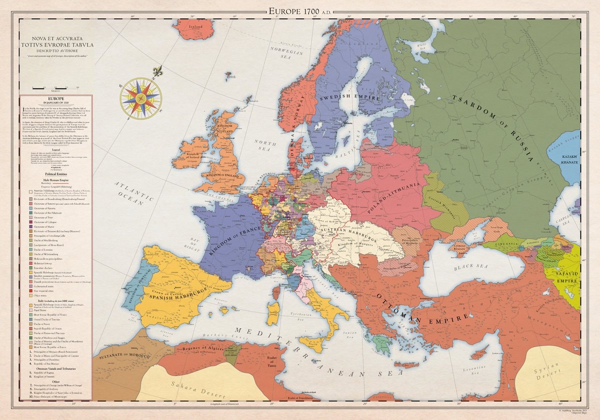
@scarlett_sA whole different map back then, Europe was something else in 1700
查看原帖@scarlett_sA whole different map back then, Europe was something else in 1700
查看原帖@scarlett_s 的照片· Aug 30, 2026· News
The image is a historical map of Europe in 1700 AD. It displays political boundaries and territories with various colors representing different empires and kingdoms. The map has a vintage aesthetic with a compass rose and a detailed legend. A notable detail is the extensive coloring of the Holy Roman Empire into many smaller states. ON-SCREEN TEXT: EUROPE 1700 A.D. NOVA ET ACCVRATA TOTIVS EVROPAE TABVLA DESCRIPTIO AVTHORE "A new and accurate map of all Europe. Description of the author." Legend Political Entities Holy Roman Empire Boundary Additional (Habsburgs, Electors, etc.) Electorate of Bavaria Electorate of Cologne Electorate of Mainz Electorate of Trier Electorate of Saxony Electorate of Brandenburg Electorate of the Palatinate Duchy of Bavaria Duchy of Saxe-Lauenburg (Saxony) Duchy of Saxe-Gotha Duchy of Saxe-Meiningen Duchy of Saxe-Weimar Principality of Ansbach Princip
 2Macklemore Palestine donation
 Berkeley RV rat outbreak
 Robert Barnes on Saudi instability
 Arizona HOA seizure outcome
 Paramount reportedly leaving California
 United States at night
 2Ed Sheeran Loop Tour ticket drop
 2Heated Rivalry Season 2 cast update
 Federal Reserve rate hike
 23-year-old boy in remission after CAR-T Cell treatment
 2Trump administration visa policy
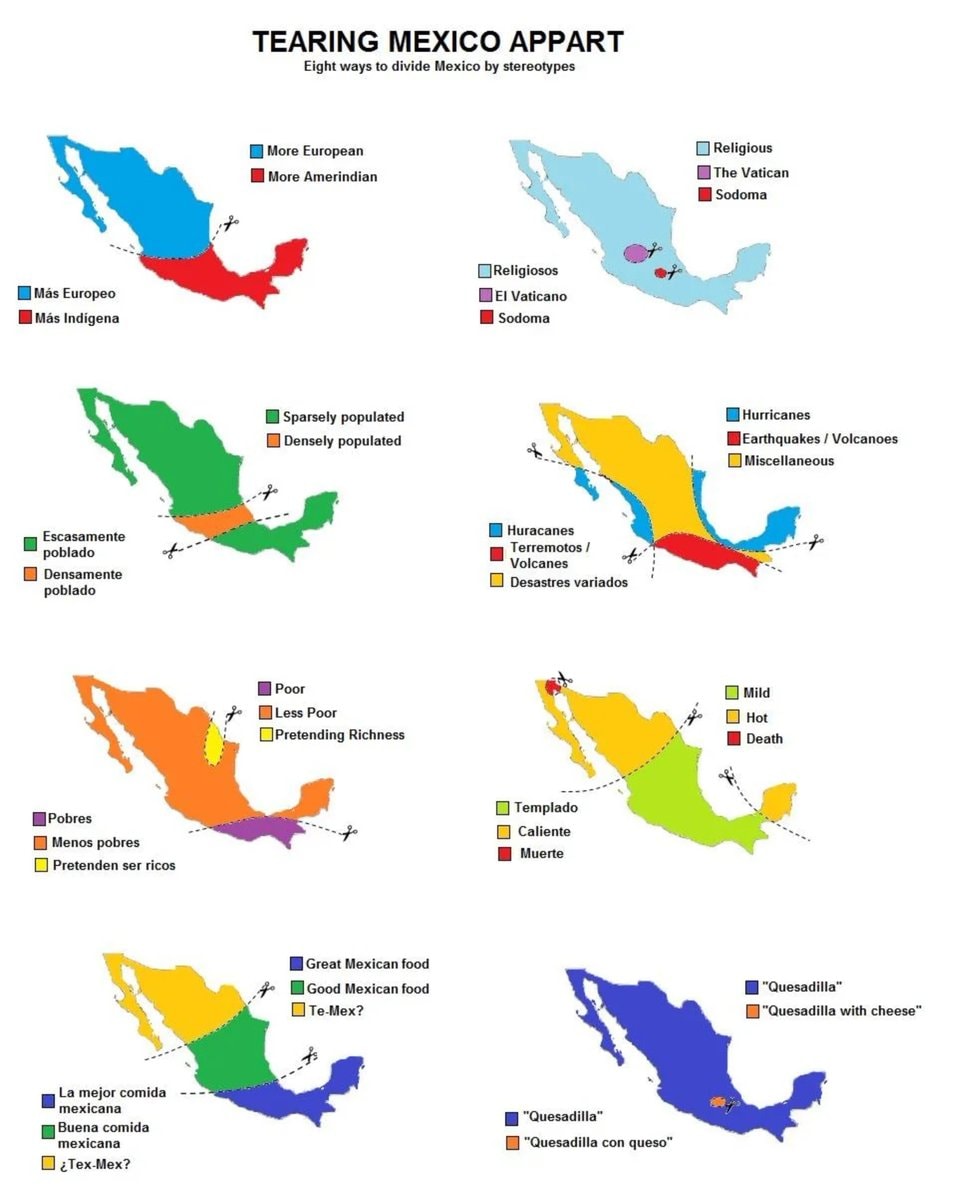 8 ways to divide Mexico by stereotype
 LA helicopter crash during coverage
 2China US outer space legal gap
 2Global renewable energy share 2025
 3Naval vessel 069 at sea
 2Ed Sheeran Loop Tour update
 2Canada EU associate member invitation
@scarlett_sA whole different map back then, Europe was something else in 1700
查看原帖@scarlett_s 的照片· Aug 30, 2026· News
The image is a historical map of Europe in 1700 AD. It displays political boundaries and territories with various colors representing different empires and kingdoms. The map has a vintage aesthetic with a compass rose and a detailed legend. A notable detail is the extensive coloring of the Holy Roman Empire into many smaller states. ON-SCREEN TEXT: EUROPE 1700 A.D. NOVA ET ACCVRATA TOTIVS EVROPAE TABVLA DESCRIPTIO AVTHORE "A new and accurate map of all Europe. Description of the author." Legend Political Entities Holy Roman Empire Boundary Additional (Habsburgs, Electors, etc.) Electorate of Bavaria Electorate of Cologne Electorate of Mainz Electorate of Trier Electorate of Saxony Electorate of Brandenburg Electorate of the Palatinate Duchy of Bavaria Duchy of Saxe-Lauenburg (Saxony) Duchy of Saxe-Gotha Duchy of Saxe-Meiningen Duchy of Saxe-Weimar Principality of Ansbach Princip
2Macklemore Palestine donationBerkeley RV rat outbreakRobert Barnes on Saudi instabilityArizona HOA seizure outcomeParamount reportedly leaving CaliforniaUnited States at night2Ed Sheeran Loop Tour ticket drop2Heated Rivalry Season 2 cast updateFederal Reserve rate hike23-year-old boy in remission after CAR-T Cell treatment2Trump administration visa policy8 ways to divide Mexico by stereotypeLA helicopter crash during coverage2China US outer space legal gap2Global renewable energy share 20253Naval vessel 069 at sea2Ed Sheeran Loop Tour update2Canada EU associate member invitation