
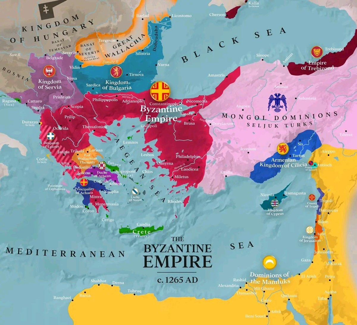
@savageupdatesThe Byzantine Empire existed around 1265 AD
查看原帖@savageupdatesThe Byzantine Empire existed around 1265 AD
查看原帖@savageupdates 的照片· Oct 6, 2026· Info/Editorials
This is a historical map depicting the Byzantine Empire around 1265 AD. The focus is on the territorial extent of the Byzantine Empire and its surrounding political entities. The map uses distinct colors to differentiate between the Byzantine Empire, the Kingdom of Hungary, the Kingdom of Serbia, the Kingdom of Bulgaria, the Mongol Dominions of Seljuk Turks, the Armenian Kingdom of Cilicia, the Dominions of the Mamluks, and other smaller principalities and duchies. The overall style is informative and educational, typical of historical cartography. A notable detail is the inclusion of various city names and geographical features like seas and rivers, along with emblems for some of the larger political powers. The on-screen text clearly labels "THE BYZANTINE EMPIRE c. 1265 AD".
 Immigrant population map by state
 Tallest men by U.S. state map
 US climate zones by location
 2Asian population share by US state
 Spain latitude comparison map
 2Global Indian ancestry population stats
 2Global plastic surgery rankings per capita
 2US State White Population Percentages
 2Hindu population rankings by country
 John across Europe map
 Top 10 Safest Countries Gallup 2025
 Life expectancy in European Countries
 2France national anthem ranking WatchMojo
@savageupdatesThe Byzantine Empire existed around 1265 AD
查看原帖@savageupdates 的照片· Oct 6, 2026· Info/Editorials
This is a historical map depicting the Byzantine Empire around 1265 AD. The focus is on the territorial extent of the Byzantine Empire and its surrounding political entities. The map uses distinct colors to differentiate between the Byzantine Empire, the Kingdom of Hungary, the Kingdom of Serbia, the Kingdom of Bulgaria, the Mongol Dominions of Seljuk Turks, the Armenian Kingdom of Cilicia, the Dominions of the Mamluks, and other smaller principalities and duchies. The overall style is informative and educational, typical of historical cartography. A notable detail is the inclusion of various city names and geographical features like seas and rivers, along with emblems for some of the larger political powers. The on-screen text clearly labels "THE BYZANTINE EMPIRE c. 1265 AD".
还没有评论。来抢沙发吧!
Immigrant population map by stateTallest men by U.S. state mapUS climate zones by location2Asian population share by US stateSpain latitude comparison map2Global Indian ancestry population stats2Global plastic surgery rankings per capita2US State White Population Percentages2Hindu population rankings by countryJohn across Europe mapTop 10 Safest Countries Gallup 2025Life expectancy in European Countries2France national anthem ranking WatchMojo
还没有评论。来抢沙发吧!